As we remembered 9/11 on the morning of September 11, 2001, we saw the following tweet:
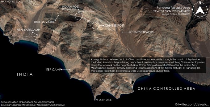
- d-atis@detresfa_ #IndianArmy high altitude maneuvers at #PangongTso visible, tracks leading up to the LAC at heights of almost 6000 Meters show a possible climb by mountaineers to preemptively overlook & observe #China PLA positions that were earlier dominating the ridgeline#IndiaChinaFaceOff
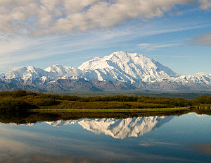
Don’t just think of the height of 6,000 meters (19,685 feet). Look below at the photo of Denali, the highest peak in North America, at 20,310 feet above the sea level at the South summit and at 19,470 feet at the North Summit.
Now imagine being a soldier or a group of soldiers living at the top of Mount Denali; not just living there but working hard every day & night to monitor what the enemy might be doing.
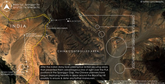
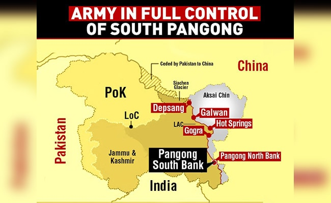
Look now at the various ridges on the South Bank of Pangong Tso that were occupied last week by elite mountain-trained soldiers of the Indian Army in one night of climbing:
- d-atis@detresfa_Reactionary deployments by #China now visible in areas around #BlackTop, large support camps crop up after action by the #IndianArmy mountaineers took positions overlooking the Spanggur Gap, minimising further surprise land grabs in the area #IndiaChinaStandoff
Who were these soldiers & how did they do it? Veteran reporter Sandeep Unnithan wrote in his September 12 article titled Border Brinkmanship in India Today,
- “Chosen for their mountaineering skills, their backpacks stuffed with water and dry rations, carrying assault rifles and ammunition, radio sets, night vision devices and hand-held thermal imagers, they were up for the long haul. The climb took them between two and three hours, their objective being to occupy a series of rolling hills along a 40-kilometre-long massif south of the lake. The features, Thakung, Gurung Hill, Magar Hill, Mukhpari, Rezang La and Rechin La, are all at altitudes of 17,000 and 18,000 feet above sea level and within India’s perception of the LAC. …. The special units bivouacked at the top, just as their comrades had done nearly half a century ago, by fashioning improvised rock shelters or sangars out of loose rocks. … The operation using a brigade of special forces, over 3,000 commandos, was the largest deployment of special forces by the Indian Army.”
This is as high as the second & highest peaks in North America, Mount Saint Elias & Mount Foraker in Alaska. Note nothing in the Rocky Mountains is above 15,000 ft. No one lives there for weeks or even thinks of spending the upcoming winter at the top of these peaks.
Militarily this has given a huge advantage to the Indian military, as a senior Army official said:
- “The Chinese might have been preparing for a level 3 or 4 game, but we have taken the game to level 9,” … We have handed them a fait accompli. If they stay, they are below us. If they launch an offensive, they are still below us”
Further as the article states:
- “The view from the heights, as Brigadier N.C. Joshi (retired), who served two tenures in the Chushul, says, is ‘breathtaking’. “You see nothing but plains all the way into Tibet.” From their perch atop the heights, Indian soldiers can see the G219 Xinjiang-Tibet road and even the PLA’s Moldo garrison in the Spanggur gap, a two-kilometer-wide valley in the mountains. An army official says the occupation of the passes bottlenecks the Chinese: “We have increased the cost for them to take back the area.”
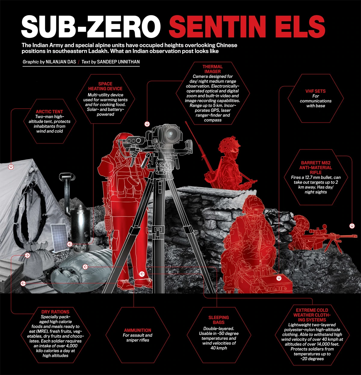
But what about the soldiers? How do they live & act on these mountain tops? Thankfully Unnithan’s article includes a picture he calls Sub-Zero Sentinels:
Taking these 17000-18000 feet heights took one night but maintaining these will take weeks if not months. That in itself will be a huge effort:
- “A logistics line, all of it relying on porters and soldiers transporting material on foot, will ensure the posts are stocked with food, water, fuel oil for cooking and heating and batteries to power their electronics.”
- “At these super-high altitudes, the enemy could not just be a sneak attack from Chinese soldiers but frostbite, sunburn, high altitude sickness and pulmonary oedema. Winter brings with it snow blizzards, where fine powder-like snow can kill humans by rapidly filling up nostrils and freezing winds can plunge the mercury to as low as 40 below zero. “
But the Indian Army may be the only army in the world that has seen worse and managed to maintain its army 365/24/7 at even a higher altitude. The Siachen Glacier is the longest (47 miles) and the highest glacier in the Karakorum range at 18,000 ft with some peaks at 20,000 feet. The Indian Army captured this glacier in a fast move in 1984 and has held it since then despite counterattacks.
This glacier is just below the tip of the pass that connects Chinese occupied Aksai Chin to Napakistan-occupied Kashmir. The northern end of the glacier opens into Daulat Beg Oldi, the airport on the tip of Ladakh, Aksai Chin & Xinjiang.
As Lt Gen. P. Ravi Shankar, former Director General Artillery, is quoted in Unnithan’s article:
- “The army, fortunately, has the valuable experience from Siachen and manning the winter posts in the Kargil sector to fall back on…. Wars are fought on capabilities and not wishlists, and these capabilities are what the army has invested in for decades at the cost of lives and comfort,”
India has maintained its army at that height & under those conditions at the top of Siachen Glacier for over 35 years. That experience will come in very handy in making sure the soldiers occupying the heights on both sides of Pangong Lake are treated well and maintained healthy now and during the coming winter.
But in one way, the situation in Pangong Tso & the Ladakh-Aksai Chin line of control may be far worse than Siachen. Because, reportedly, “both sides have deployed close to 50,000 armed soldiers, backed by artillery and tanks, within shooting distance of each other“. And local commanders have been given the authority to act because “many units are deployed in isolated places where the army does not exercise centralized command and control“.
And the worst may be yet to come. As Unnithan explains in his article:
- “The next two months will be critical for the Indian side. October and November are seen as the ‘campaign season’ in the Himalayas, the best months to launch offensives before the onset of winter blocks the mountain passes. This is the reason the PLA chose to launch their 1962 border offensive in Arunachal Pradesh and Ladakh during these months.”
This is why we are dedicating this article to the soldiers on both sides who are stationed in almost inhumane conditions at 17,000-18,000 feet.
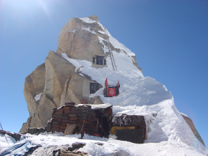
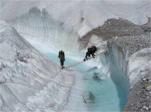
Editor’s PS: We strongly recommend reading the above-mentioned article by Sandeep Unnithan titled Border Brinkmanship. Those who want a glimpse of what it took to master the art of living & working on the Siachen glacier should take a look at our review of the book Beyond NJ 9842 – The SIACHEN Saga by the veteran journalist Nitin Gokhale. Below are a couple of photos Mr. Gokhale authorized us to use in our review. Get the book & read it would be our recommendation:
Send your feedback to editor@macroviewpoints.com Or @MacroViewpoints on Twitter